Precision mapping
| dc.date.accessioned | 2007-02-09T10:39:09Z | |
| dc.date.available | 2007-02-09T10:39:09Z | |
| dc.date.issued | 2000 | |
| dc.identifier.issn | 1435-0645 | |
| dc.identifier.issn | 0002-1962 | |
| dc.identifier.uri | urn:nbn:de:hebis:34-2007020917138 | |
| dc.identifier.uri | http://hdl.handle.net/123456789/2007020917138 | |
| dc.format.extent | 233764 bytes | |
| dc.format.mimetype | application/pdf | |
| dc.language.iso | eng | |
| dc.rights | Urheberrechtlich geschützt | |
| dc.rights.uri | https://rightsstatements.org/page/InC/1.0/ | |
| dc.subject.ddc | 630 | |
| dc.title | Precision mapping | eng |
| dc.type | Aufsatz | |
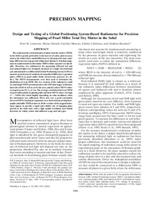
| dcterms.abstract | The nondestructive determination of plant total dry matter (TDM) in the field is greatly preferable to the harvest of entire plots in areas such as the Sahel where small differences in soil properties may cause large differences in crop growth within short distances. Existing equipment to nondestructively determine TDM is either expensive or unreliable. Therefore, two radiometers for measuring reflected red and near-infrared light were designed, mounted on a single wheeled hand cart and attached to a differential Global Positioning System (GPS) to measure georeferenced variations in normalized difference vegetation index (NDVI) in pearl millet fields [Pennisetum glaucum (L.) R. Br.]. The NDVI measurements were then used to determine the distribution of crop TDM. The two versions of the radiometer could (i) send single NDVI measurements to the GPS data logger at distance intervals of 0.03 to 8.53 m set by the user, and (ii) collect NDVI values averaged across 0.5, 1, or 2 m. The average correlation between TDM of pearl millet plants in planting hills and their NDVI values was high (r^2 = 0.850) but varied slightly depending on solar irradiance when the instrument was calibrated. There also was a good correlation between NDVI, fractional vegetation cover derived from aerial photographs and millet TDM at harvest. Both versions of the rugged instrument appear to provide a rapid and reliable way of mapping plant growth at the field scale with a high spatial resolution and should therefore be widely tested with different crops and soil types. | eng |
| dcterms.accessRights | open access | |
| dcterms.alternative | Design and testing of a Global Positioning System-based radiometer for precision mapping of pearl millet total dry matter in the Sahel | eng |
| dcterms.bibliographicCitation | In: Agronomy journal. Madison, Wis. : American Society of Agronomy. 92.2000, S. 1086-1095 | |
| dcterms.creator | Lawrence, Peter R. | |
| dcterms.creator | Gérard, Bruno | |
| dcterms.creator | Moreau, Caroline | |
| dcterms.creator | Lhériteau, Fabrice | |
| dcterms.creator | Bürkert, Andreas | |
| dc.subject.swd | Sahel | ger |
| dc.subject.swd | Perlhirse | ger |
| dc.subject.swd | Trockenmasse | ger |
| dc.subject.swd | GPS <Satellitengeodäsie> | ger |
| dc.subject.swd | Kartierung | ger |
Dateien zu dieser Ressource
Das Dokument erscheint in:
-
Publikationen [36]